The ice winter 2021/2022 at the German coasts and the Baltic Sea
Table of Content
- 1 Overview of the ice winter 2021/22
- 2 The ice winter at the German North Sea and Baltic Sea coasts
- 2.1 Weather conditions at the German coastal areas
- 2.2 Ice conditions at the German North Sea and Baltic Sea coasts
- 2.3 Navigational conditions at the German North Sea and Baltic Sea coasts
- 2.4 Ice winter severity
- 3 Ice conditions in the western and southern Baltic Sea, Kattegat and Skagerrak
- 4 Ice conditions in the northern Baltic Sea
- 5 The ice winter 2021/22 in long-term comparison
- 6 Reporting of the BSH
- Bibliography
- Appendix
1 Overview of the ice winter 2021/22
The ice winter 2021/2022 at the German North Sea and Baltic Sea coast was a weak ice winter. Noticeable ice formation occurred only in sheltered places along the Baltic Sea coast and the Szczecin Lagoon for a short-period at the end of December. Warm temperatures at the turn of the year quickly ended the ice occurrence. The ice winter for the entire Baltic Sea was a weak ice winter with respect to the maximum sea ice extent. The length of the ice season in the northern part of the Bay of Bothnia from the first ice formation in October to the melting of the last ice beginning of June was comparatively long. In other regions of the Baltic Sea the ice season was mostly shorter than on average.2 The ice winter at the German North Sea and Baltic Sea coast
2.1 Weather conditions at the German coastal areas
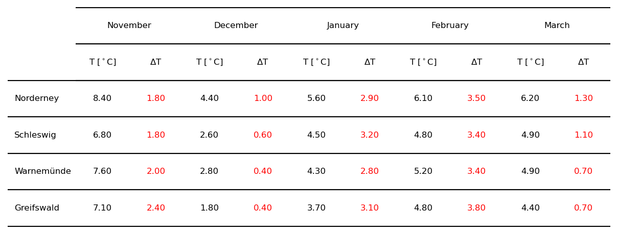
The winter 2021/22 in Germany was the eleventh winter in a row that was too warm [1]. This is underlined by the comparison of the monthly mean air temperatures with the long-term mean values of the reference period 1981-2010 for four weather stations along the German coast in Table 1. All monthly mean values were above the values of the reference period. The largest deviation occurred for January and February was the with 2.8 °C to 3.8 °C. For December and March the deviations were around 0.4 °C to 1.3 °C.
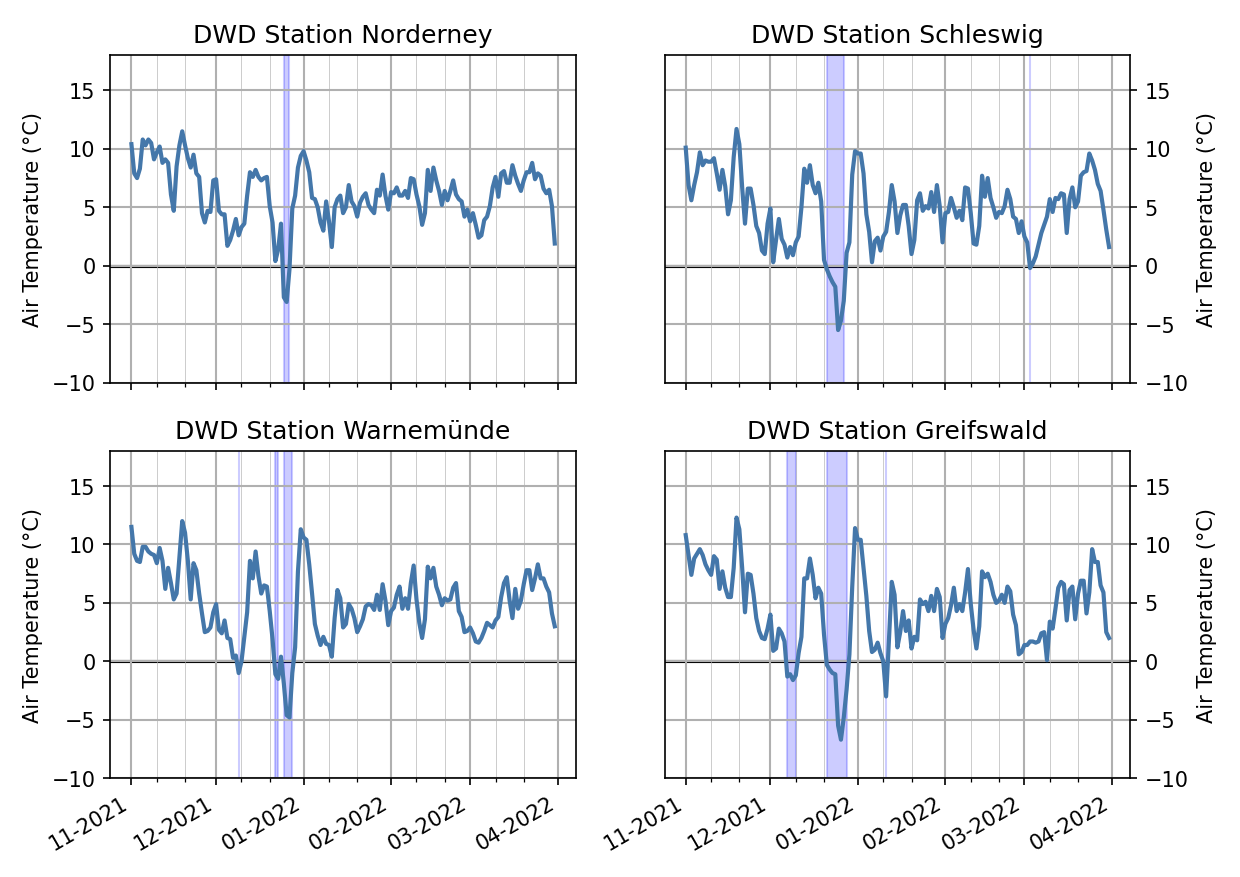
The weather situation during the winter is shown in more detail by the daily mean air temperatures of these four weather stations in Figure 1. In December warmer and colder periods were alternating and the first daily mean air temperatures below freezing occurred around 10th December 2021 at the eastern stations. However, temperatures increased significantly after this short cold period. Cold airmasses of Polar origin reached Germany around the 20th December 2021 [2]. At all four stations, daily mean temperatures below 0 °C occurred some days later (see areas highlighted in blue in Figure 1). Particularly cold temperatures were measured at the stations in Schleswig and Greifswald. There was mostly moderate frost with severe frost at places and permanent frost occurred locally. Around the turn of the year temperatures rose quickly and two-digit daily mean air temperatures were reached at places. Daily mean air temperatures remained, with only a few exemptions, above the freezing point for the rest of the winter. Only at the beginning of March, there were a few days with night frost and generally colder temperatures.
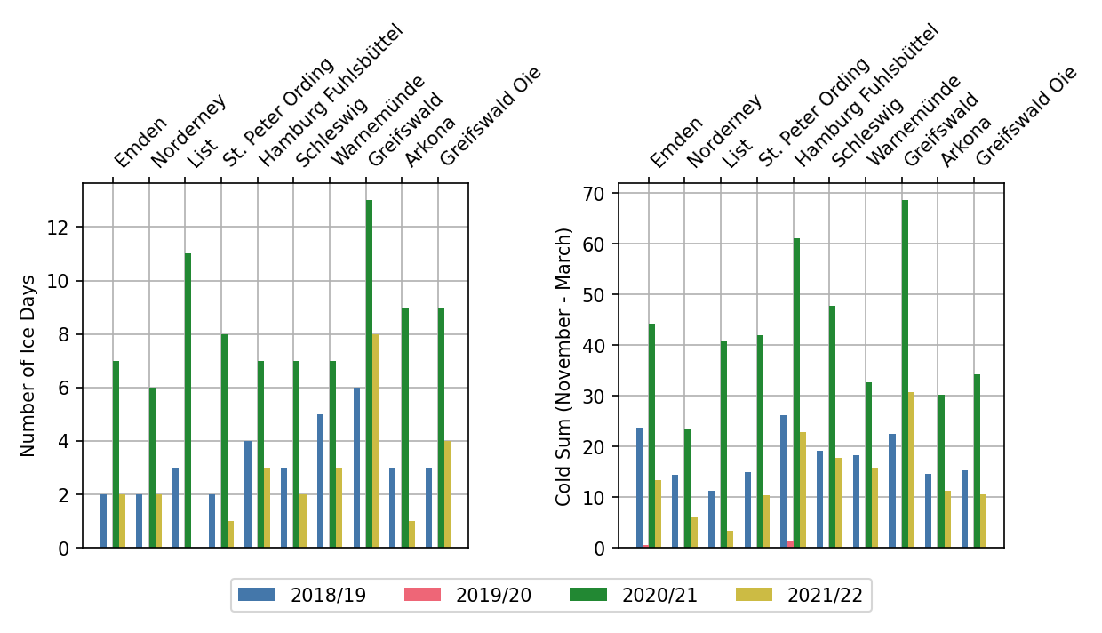
The number of ice days, days with maximum temperature below 0 °C, and the cold sum, the absolute value of the sum of negative daily mean temperatures, for a number of weather stations are shown in Figure 2. The number of ice days in the winter 2021/22 is mostly lower than the number in previous winters; only Greifswald and Greifswalder Oie had more ice days than 2018/19. The very warm winter of 2019/20 had no ice days at all. The cold sum is a measure for the strength of the winter. The last four winters are all classified as a mild winter with a cold sum below 100 for the months November to March.
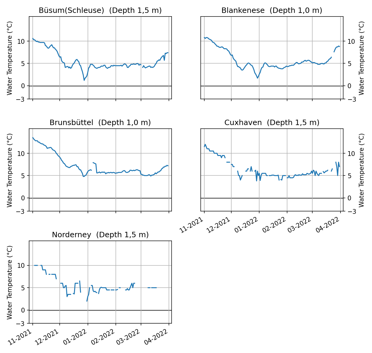
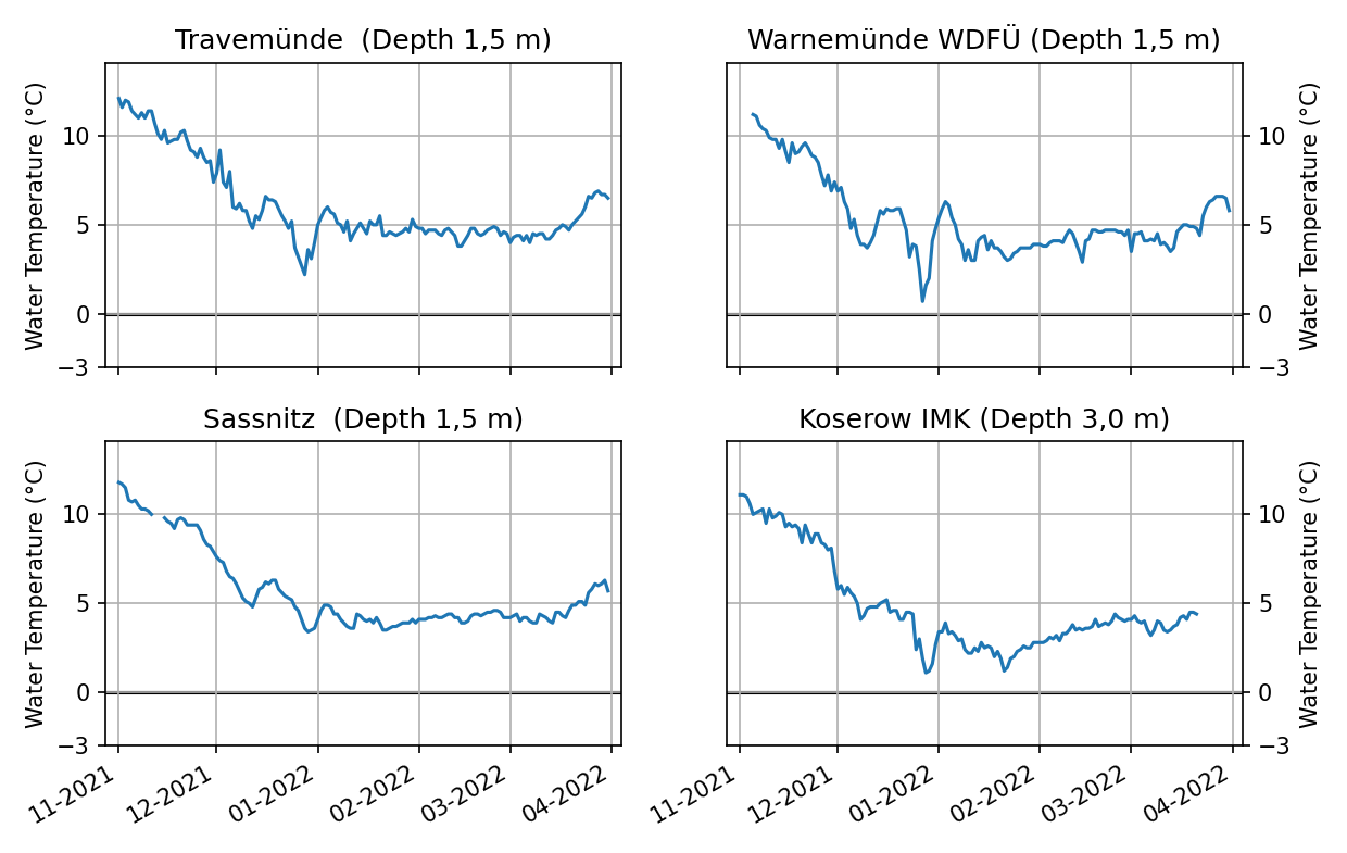
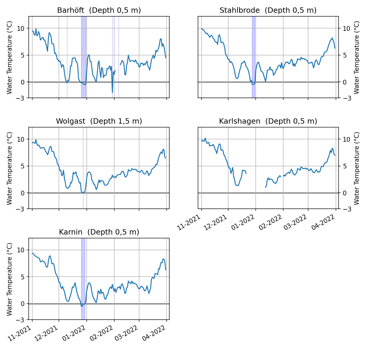
The water temperatures along the coast are shown in the Figures 3-5. In November and December, the water temperatures decreased constantly. The air temperature variabilities in December are also reflected in the water temperatures and most pronounced in the Bodden waters and the Szczecin Lagoon. Most of the stations reach their minimum temperature with the cold weather period at the end of December. Along the North Sea coast and the outer coastal areas, the water temperatures stayed well above 0°C for the entire winter and remained constant throughout January and February before water temperatures started rising end of March. In the Bodden waters around Rügen and the Szczecin Lagoon water temperatures below 0°C were measured during the cold period at the end of December (see areas highlighted in blue in Figure 6). In those waters temperatures started to raise slowly mid/end January and then significantly in the second half of March. The water temperatures show that ice formation was only possible in sheltered places and for a very short period. At the outer coast and the North Sea coast temperatures were too high for ice formation.
2.2 Ice conditions at the German North Sea and Baltic Sea coasts
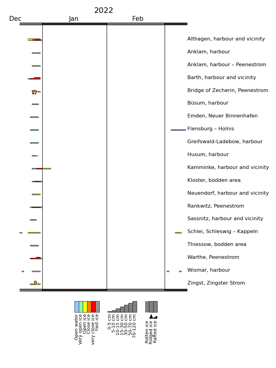
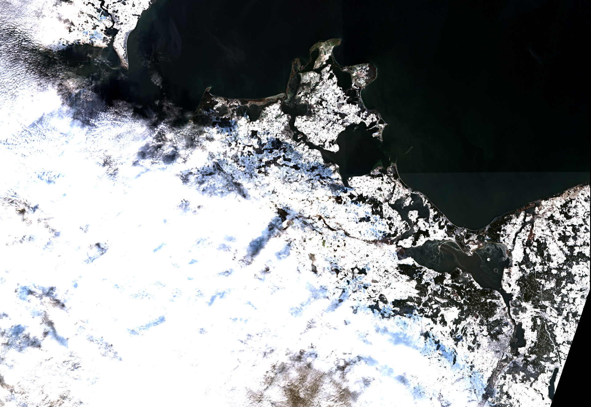
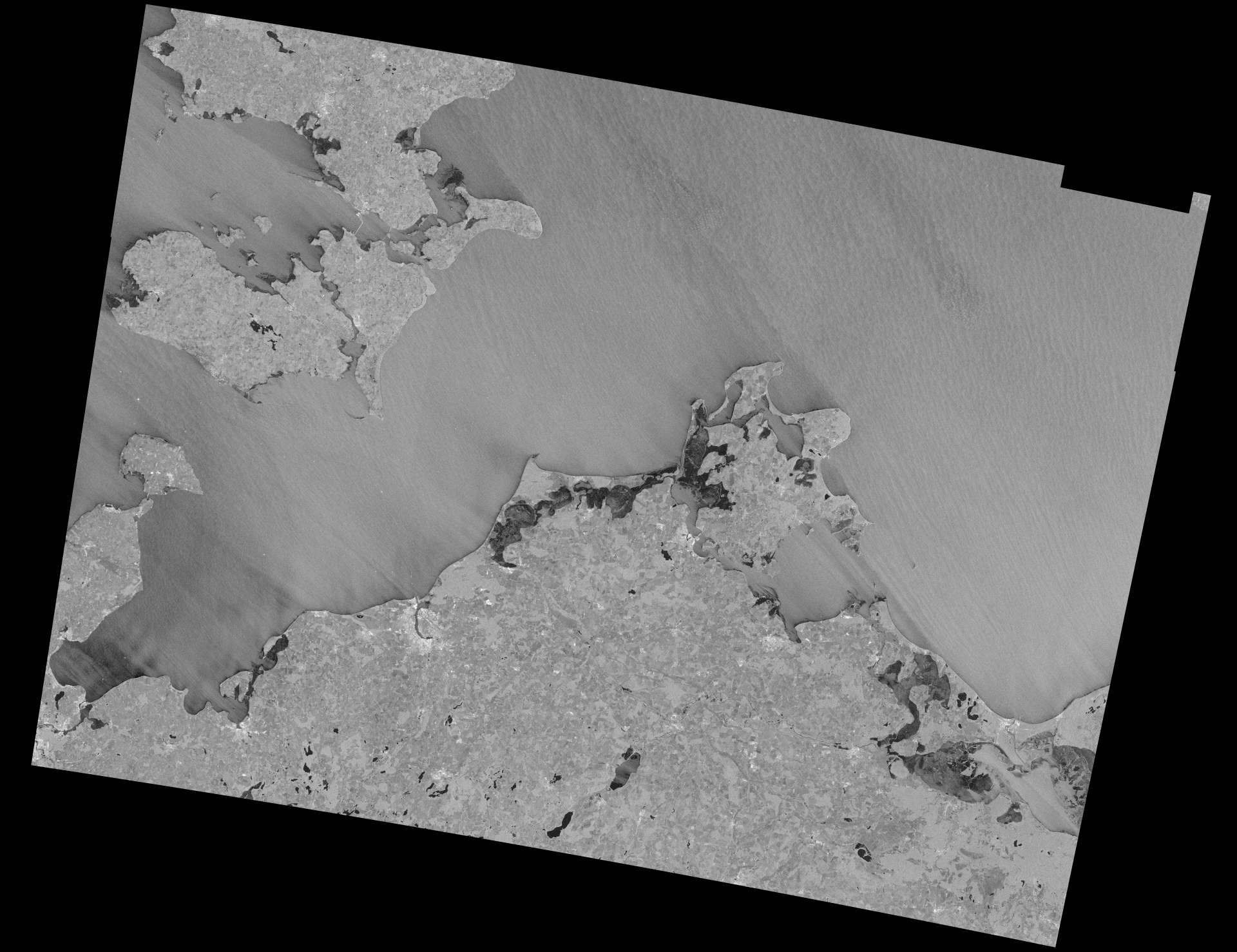
The ice winter 2021/22 in the German coastal waters was a very short one. With the cold weather period end of December and the accordingly low air temperatures ice formation started in the Schlei at 21st December 2021 and in the harbour of Wismar on 22nd December 2021. At first the ice could not persist and around 25th/26th December 2021 ice formation started in sheltered places along the coast of Mecklenburg-Vorpommern, the Schlei and the Flensburg Fjord. The ice situation along the eastern coast at 27th December 2021 is nicely shown in an optical image of Sentinel-2 (Figure 6) and a radar image of Sentinel-1 (Figure 7). In the optical image, ice formation is visible by white structures with a dark background especially in the Szczecin Lagoon. In the Darß-Zingst Bodden Chain ice formation is hardly noticable in the image without zooming in. In the radar image, the ice formation at the Szczecin Lagoon, the Darß-Zingst Bodden Chain and the Salzhaff is clearly visible by the darker tone that is caused by dampening of surface waves due to ice formation.
At the North Sea coast, ice was only observed at the harbours of Büsum, Husum and Emden after the Christmas holidays. With significantly warmer temperatures above the freezing point and partly rainy weather over the turn of the year the ice vanished quickly. Only in the Szczecin Lagoon ice persisted at places until 4th January 2022. Due to the relative cold air temperatures and persistent frost for a few days, the ice reached up to 10 cm thickness in sheltered areas. The cold temperatures with night frost at the beginning of March caused some new ice formation in the Flensburg Fjord, the Schlei and the harbour of Wismar. The ice did mostly not survive the day.
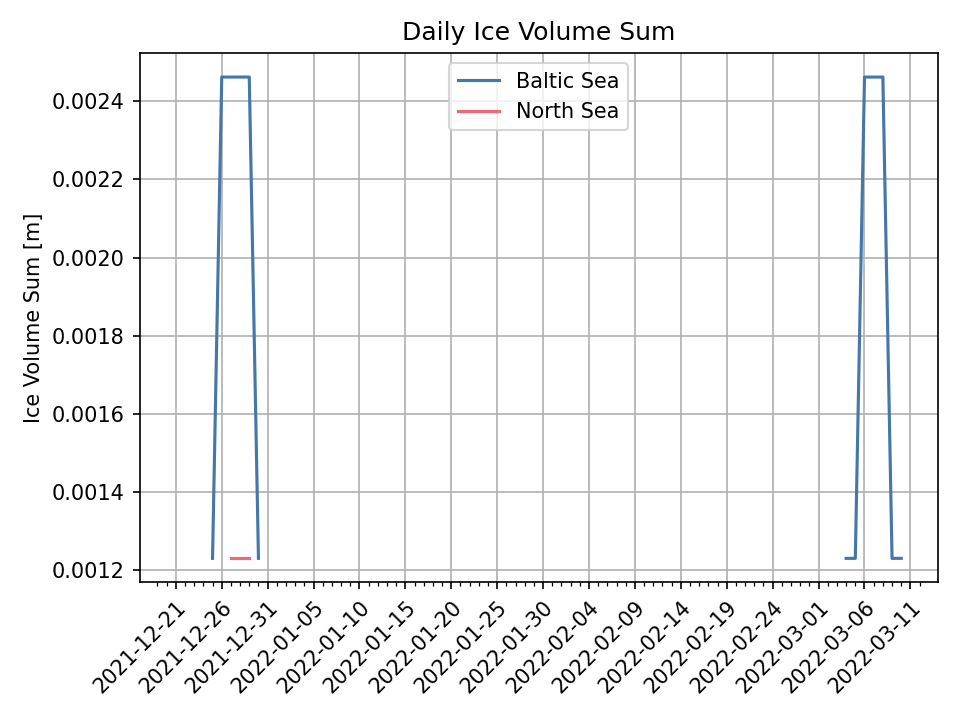
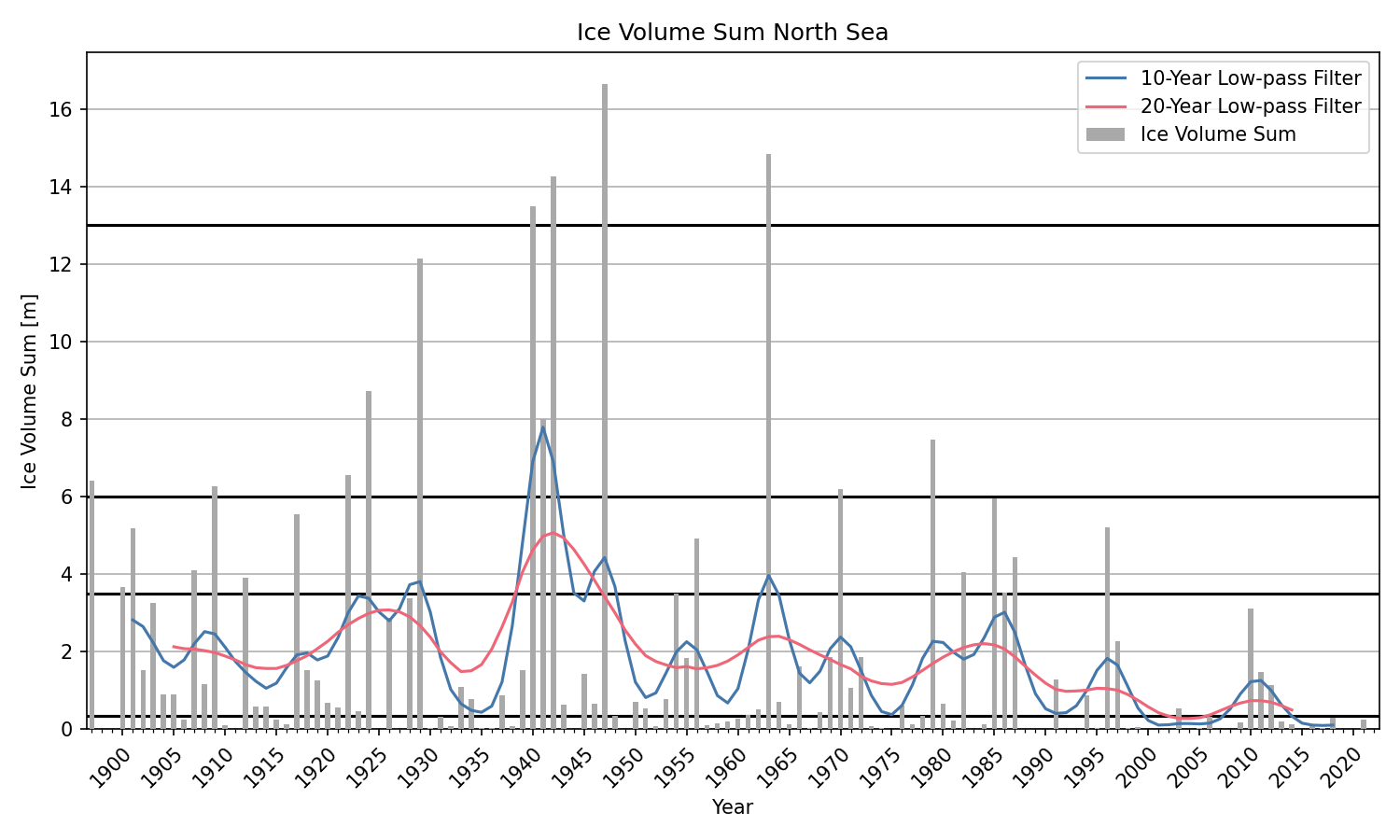
The course of the ice winter is also reflected by the daily areal ice volume sum of 13 ice climatological stations along the North Sea and Baltic Sea coast, respectively; shown in Figure 8. The two short periods of ice formation at the end of December and beginning of March in the Baltic Sea and at the end of December in the North Sea are clearly visible. The ice climatological stations are Borkum/Westerems, Emden (Ems and outer harbour), Norderney/Seegat, Wangerooge/wadden, Hohe Weg/lighthouse, Brake (Weser), Helgoland, Stadersand/Elbe, Brunsbüttel, Hamburg/Landungsbrücken, Husum (harbour), Amrum/Schmaltief und Tönning (harbour) for the North Sea and Koserow, Arkona, Landtiefrinne, Vierendehlrinne, Warnemünde/sea area, Rostock-Warnemünde, Walfisch-Timmendorf, Travemünde-Lübeck, Marienleuchte/sea area, Westermarkelsdorf/sea area, Eckernförde (harbour), Schleimünde-Schleswig und Flensburg-Holnis for the Baltic Sea. The areal ice volume sum is a characteristic number to determine the ice winter strength along the German coasts, which is calculated from the ice concentration, the ice thickness and the duration of the ice occurrence [3]. Husum (harbour) was the only climatological station at the North Sea that reported ice during this winter. In the Baltic Sea, Flensburg-Holnis and Schleimünde-Schleswig were the only stations to report ice. The choice of the climatological stations diminishes the difference between the two short cold weather periods because the stations in the Szczecin Lagoon and the inner Bodden waters are not considered in the calculation of the areal ice volume sum.
2.3 Navigational conditions at the North Sea and Baltic Sea
Navigation in German coastal waters was not noticable impacted by the ice conditions in the winter 2021/22. Small craft and leisure boat traffic was locally hampered by the ice conditions.
2.4 Ice winter severity
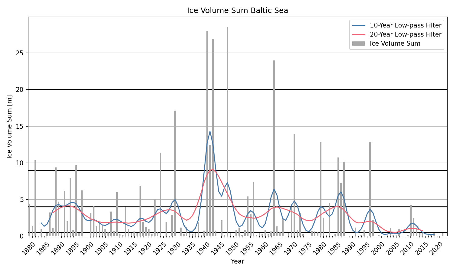
The ice winter severity at the German North Sea and Baltic Sea coasts is determined by the accumulated areal ice volume sum of the 13 respective ice climatological ice stations (see 2.2). The accumulated areal ice volume sum of the winter 2021/22 is shown in Figure 9 for the North Sea and Baltic Sea. At the North Sea an areal ice volume of 0.004 m and at the Baltic Sea of 0.026 m is obtained. Therefore, these were the tenth weak ice winters in a row at the North Sea and Baltic Sea, as shown in Figures 9 and 10. The black lines in the figures denote the boundaries for weak, moderate, severe, very severe and extremely severe ice winters.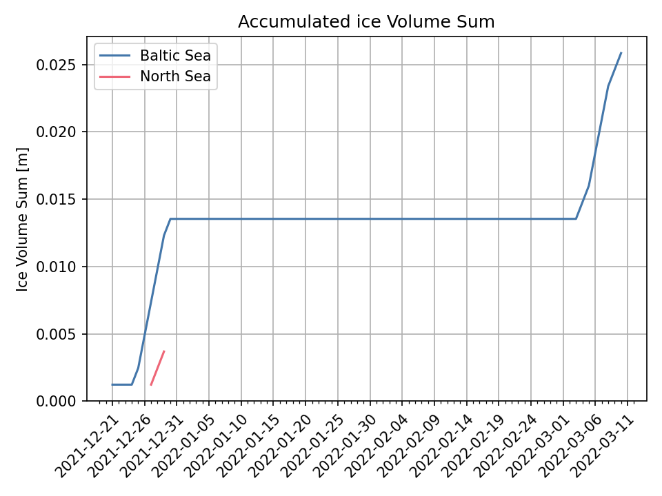
3 Ice conditions in the western and southern Baltic Sea, Kattegat and Skagerrak
In the Skagerrak, ice has formed locally in sheltered bays along the Norwegian coast and sporadically along the Swedish coast from December into March. At a few very sheltered places, thicker fast ice occurred along the Norwegian coast. Along the Danish islands and coast, new ice formed occassionally during the winter but never survived a longer period. In the southern Baltic Sea, ice formed in the Szczecin Lagoon around 26th December 2021. The last ice melted shortly after New Year. Along the outer coasts of the southern and southeastern Baltic Sea and the southern Swedish coast no noteworthy ice has formed during the winter. Navigation was mostly unobstructed. Only in some smaller Norwegian fjords navigation was impeded or temporarily closed due to the ice conditions.
4 Ice conditions in the northern Baltic Sea
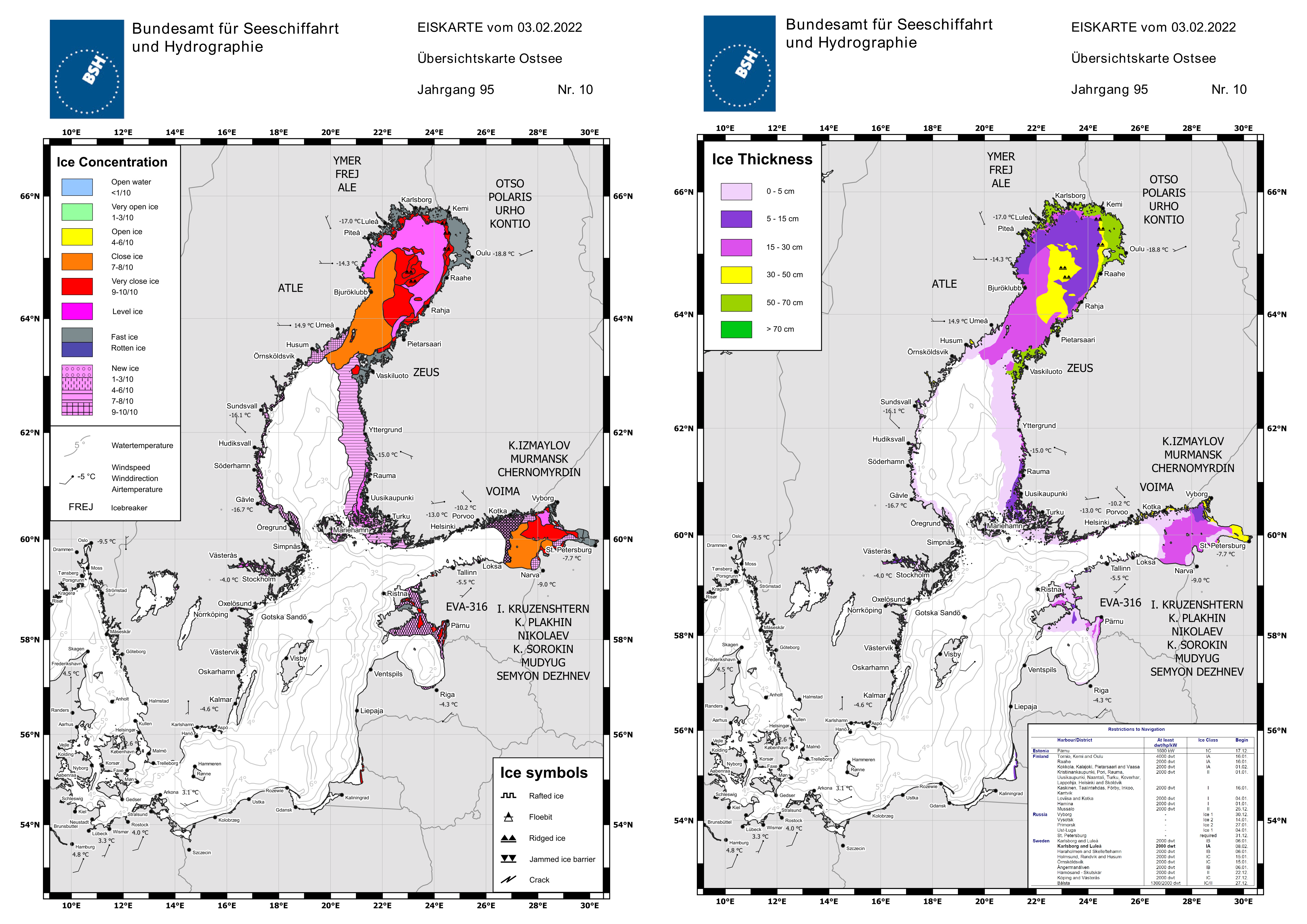
The ice season in the northern Baltic Sea was comparatively long. The first ice formed in the northern Bay of Bothnia end of October and the last ice disappeared there by the beginning of June. Further south, ice formation started earlier than usual at places but the ice season was mostly shorter than expected. Comparatively little ice formed at sea this winter. In the coastal regions however, the ice remained more or less continuously throughout the winter season. The first ice of the season formed in the northern Bay of Bothnia by the end of October. But it was not before the end of November that ice formed outside sheltered coastal areas. At that time, ice formation started also further south along the coasts of the southern Bay of Bothnia and the northern Sea of Bothnia, sheltered areas in Norra Kvarken as well as in Lake Mälaren. New ice formation in the eastern Gulf of Finland and the northern Gulf of Riga started early December. In the course of December ice formation was mostly limited to the coastal areas. The ice continuously persisted in those areas and the first fast ice formed in the northern Bay of Bothnia, Norra Kvarken and the eastern Gulf of Finland. With the beginning of January ice formation extended further out at sea in the Bay of Bothnia and the eastern Gulf of Finland. The ice could not persist at sea in the north, because higher winds destroyed the new ice or the ice drifted away. In the Gulf of Finland, the ice extended to approximately the island Seskar. At the end of January/beginning of February cold temperatures facilitated ice formation and ice growth and the maximum ice extent was reached on 3rd/4th February 2022. The ice situation at that time is shown by the BSH ice chart of 3rd February 2022 in Figure 12. At that time, the entire Bay of Bothnia and Norra Kvarken were covered by 5–20 cm thick ice, but at places the drift ice was up to 50 cm thick. Along the coast, there was up to 70 cm thick fast ice. In the Sea of Bothnia, there was fast ice along the coast and new ice further out in the east. The sea however was ice free. In the Gulf of Finland, there was fast ice along the northern and eastern coast and at sea, there was 5–30 cm thick drift ice up to the lighthouse Rodser. In the northeastern Gulf of Riga, there was thin ice in Väinameri and drift ice from Saaremaa to Pärnu. Along the Swedish coast of the northern Baltic, there was new ice at places. Further south there were only remnants of ice in the Curonian Lagoon.
Restrictions of navigation regarding ice class and ship size/deadweight in the northern Bay of Bothnia were in place from 4th December 2021 to the 25th May 2022. At times, there were also restrictions in the Sea of Bothnia, the Gulf of Finland and the Gulf of Riga. Several icebreakers were deployed for navigational assistance. The Saimaa Canal was closed from 30th January 2022 to 30th April 2022. The traffic separation scheme in Norra Kvarken was out of use from 15th January to 2nd May 2022.
5 Ice winter severity of the Baltic Sea
The ice winter severity of the entire Baltic Sea is determined by the maximum ice extent. The maximum ice extent was reached on 4th February 2022 according to the Finnish and Swedish ice services and was about 93000 km2. The maximum ice extent in the ice charts of the BSH was reached on 3rd February with 87410 km2. The differences in the ice extent stem from different land masks, differences in satellite data interpretation as well as different methods of determining the maximum ice extent, but the generally follow the same trend. This is shown by a time series of maximum sea ice extent from the Finnish Ice Service and the BSH in Figure 13.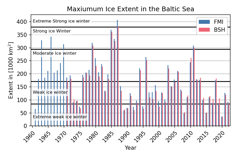
6 Reporting of the BSH
The BSH informed about ice conditions and expected ice development in the entire Baltic Sea and German coastal waters by the following reports and ice charts:
- Ice reports (Amtsblatt, official report issued Monday - Friday)
- German Ice Reports (Information about ice conditions in German fairways)
- Baltic Sea reports (detailed description of the ice situation along the German Baltic Sea coast)
- North Sea reports (detailed description of the ice situation along the German Baltic Sea coast)
- Weekly reports (Review and outlook of the ice situation)
- Ice charts of the German coastal areas and Skagerrak (up to daily)
- Ice charts of the German coastal areas and Skagerrak (up to daily)
- Ice charts of the German Baltic Sea coast (up to daily)
Bibliography
- Deutscher Wetterdienst (2022, 28. Februar), Deutschlandwetter im Winter 2021/22 [Pressemitteilung], https://www.dwd.de/DE/presse/pressemitteilungen/DE/2022/20220228_deutschlandwetter_winter2022_news.html
- Haeseler, S., Der Wetterlotse, Ausgabe 6/2021, Deutscher Wetterdienst
- Koslowski, G., 1989: Die flächenbezogene Eisvolumensumme, eine neue Maßzahl für die Bewertung des Eiswinters an der Ostseeküste Schleswig-Holsteins und ihr Zusammenhang mit dem Charakter des meteorologischen Winters. Dt. hydrogr. Z. 42, 61-80
- Nusser, F., 1948: Die Eisverhältnisse des Winters 1947/48 an den deutschen Küsten. Dt. hydrogr. Z. 1, 149–156
Appendix
A. Ice conditions at the German coasts
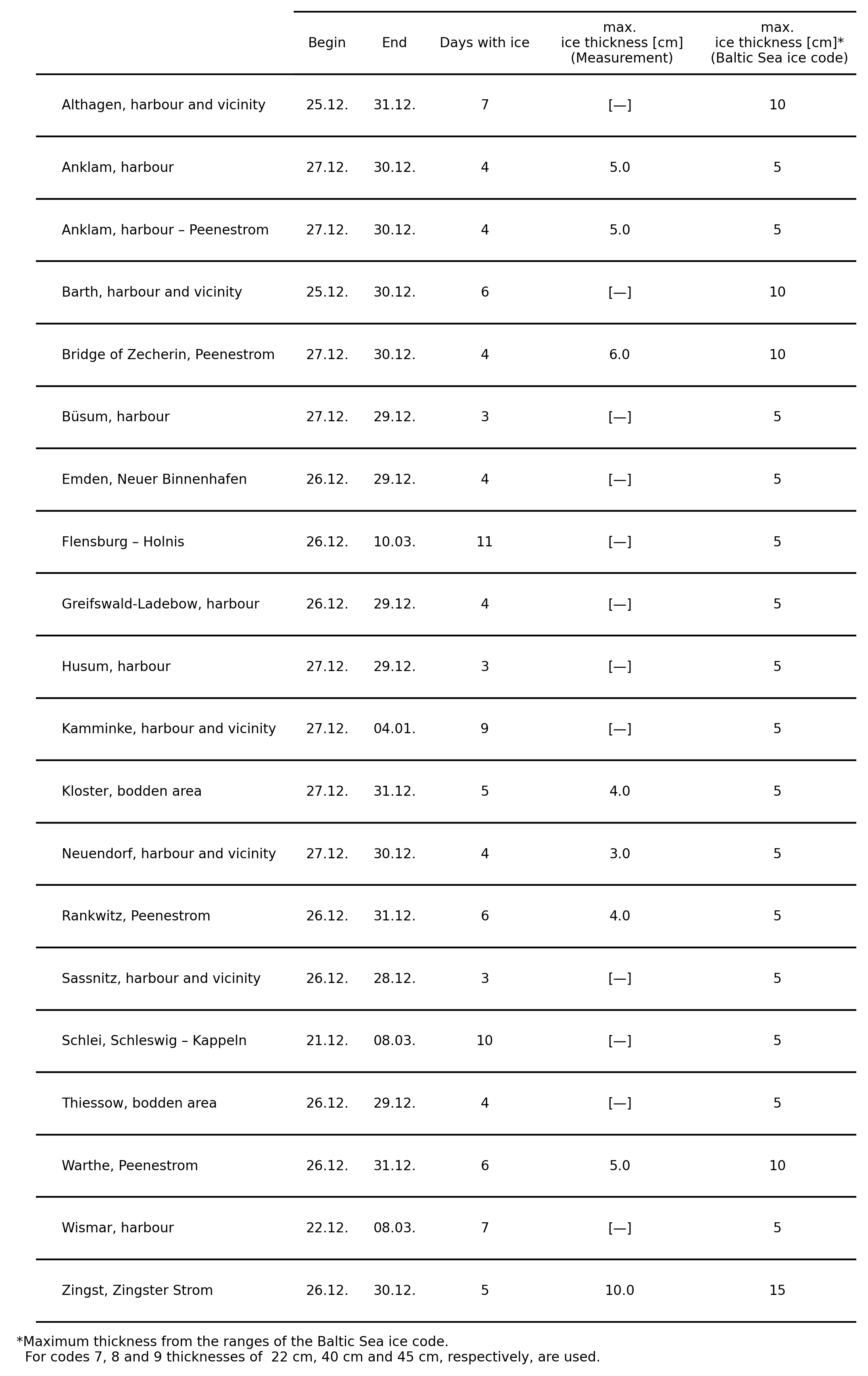
B. Baltic Sea ice codes German stations