The ice winter 2022/2023 at the German coasts and the Baltic Sea
Wiebke Aldenhoff
Table of Content
- 1 Overview of the ice winter 2022/23
- 2 The ice winter at the German North Sea and Baltic Sea coasts
- 2.1 Weather conditions at the German coastal areas
- 2.2 Ice conditions at the German North Sea and Baltic Sea coasts
- 2.3 Navigational conditions at the German North Sea and Baltic Sea coasts
- 2.4 Ice winter severity
- 3 Ice conditions in the western and southern Baltic Sea, Kattegat and Skagerrak
- 4 Ice conditions in the northern Baltic Sea
- 5 The ice winter 2022/23 in long-term comparison
- 6 Reporting of the BSH
- Bibliography
- Appendix
1 Overview of the ice winter 2022/23
The ice winter 2022/23 at the German North and Baltic Sea coasts was the eleventh weak ice winter and the twelfth too warm winter in a row. Noteworthy ice formation along the coasts occurred only during a cold period in December. At the Baltic Sea coast, a closed ice cover formed in the Szczecin Lagoon and the Bodden waters around Rügen and the Darß. Else, there was mostly new ice and some thicker ice at sheltered places along the coast. In the North Sea, new ice formed occasionally. In the beginning of February some marginal ice was present along the shores in the Bodden waters.The ice winter in the Baltic Sea was a mild ice winter regarding the ice extent. Nevertheless, at the time of maximum ice extent the Bay of Bothnia, the coast of the Sea of Bothnia, the Gulf of Finland to Gogland and the north-eastern part of the Gulf of Riga were covered with ice. In the Bay of Bothnia, the ice season was slightly longer than usual; further south however it was mostly shorter.
2 The ice winter at the German North Sea and Baltic Sea coast
2.1 Weather conditions at the German coastal areas
The winter 2022/2023 was the twelfth too warm winter in Germany in a row [1]. This is underlined by the comparison of the monthly mean air temperatures with the reference period from 1981–2010. These are shown in Table 1 for the four stations Norderney, Schleswig, Warnemünde und Greifswald. With the exception of December 2022, all monthly mean temperatures were higher than in the reference period. Especially in January and February 2023 it was significantly warmer than usual. The monthly mean temperatures were 3 °C to 3.7 °C and 1.9 °C to 3.1°C, respectively, warmer than usual. In December, however, it was colder than usual along the east coast with deviations from -0.3 °C to 0 °C from the reference period. In the North Sea, monthly mean temperatures were only slightly warmer.
| November | December | January | February | March | ||||||
|---|---|---|---|---|---|---|---|---|---|---|
| T [°C] | ΔT | T [°C] | ΔT | T [°C] | ΔT | T [°C] | ΔT | T [°C] | ΔT | |
| Norderney | 8.20 | 1.60 | 3.70 | 0.20 | 5.60 | 3.00 | 5.70 | 3.10 | 6.40 | 1.50 |
| Schleswig | 6.90 | 1.90 | 2.00 | -0.00 | 4.40 | 3.10 | 4.00 | 2.60 | 5.10 | 1.30 |
| Warnemünde | 7.20 | 1.60 | 2.10 | -0.30 | 4.90 | 3.40 | 3.70 | 1.90 | 5.70 | 1.50 |
| Greifswald | 6.40 | 1.70 | 1.10 | -0.30 | 4.30 | 3.70 | 3.00 | 2.00 | 5.20 | 1.50 |
The weather situation during the winter is shown in more detail by the daily mean air temperature for the four stations Norderney, Schleswig, Warnemünde and Greifswald from November 2022 to April 2023 in Figure 1. At the beginning of November, the daily mean air temperatures were in the two-digit range. With the beginning of the last third of November, first negative daily mean temperatures were observed along the Baltic Sea coast but temperatures quickly rose again. Towards the end of the first third of December, temperatures were dropping quickly by the influence of polar air and permanent frost occurred locally [2]. These weather conditions lasted until 18 December 2022. Afterwards the trough of a low-pressure system caused quickly rising temperatures and rain. Daily mean temperatures increases of up to 10 °C within two days were quite common. In the following time, daily mean temperatures stayed well above the freezing point and at the turn of the year, they were in the two-digit positive range. The warm weather continued in the beginning of January. Towards the end of the second third of January, temperatures fell again and locally daily mean temperatures below the freezing point occurred. In the beginning of February, there was a period of colder temperatures followed by daily mean temperatures mostly above the freezing point. At the beginning of March, temperatures were colder again but stayed well above the freezing point afterwards.
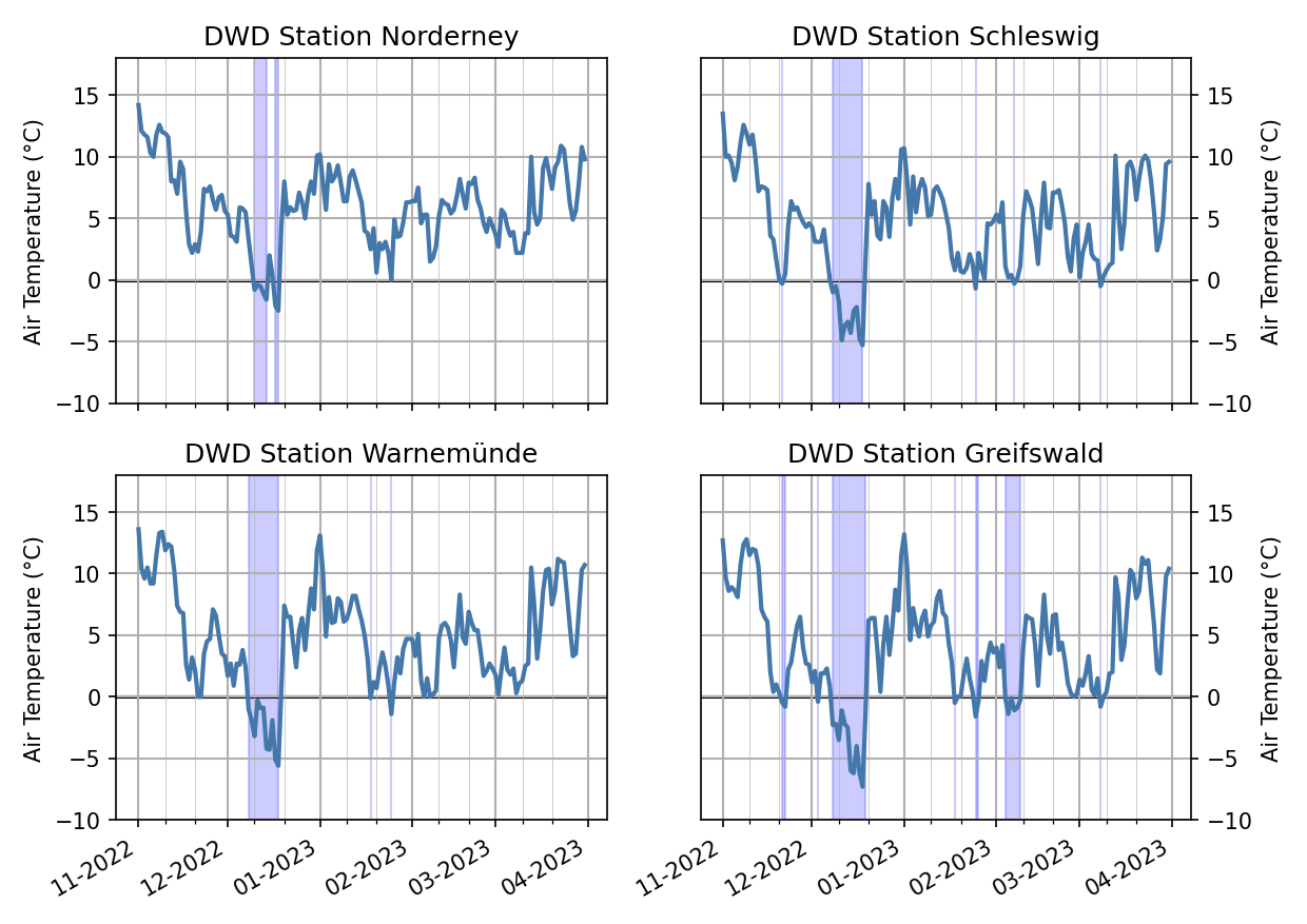
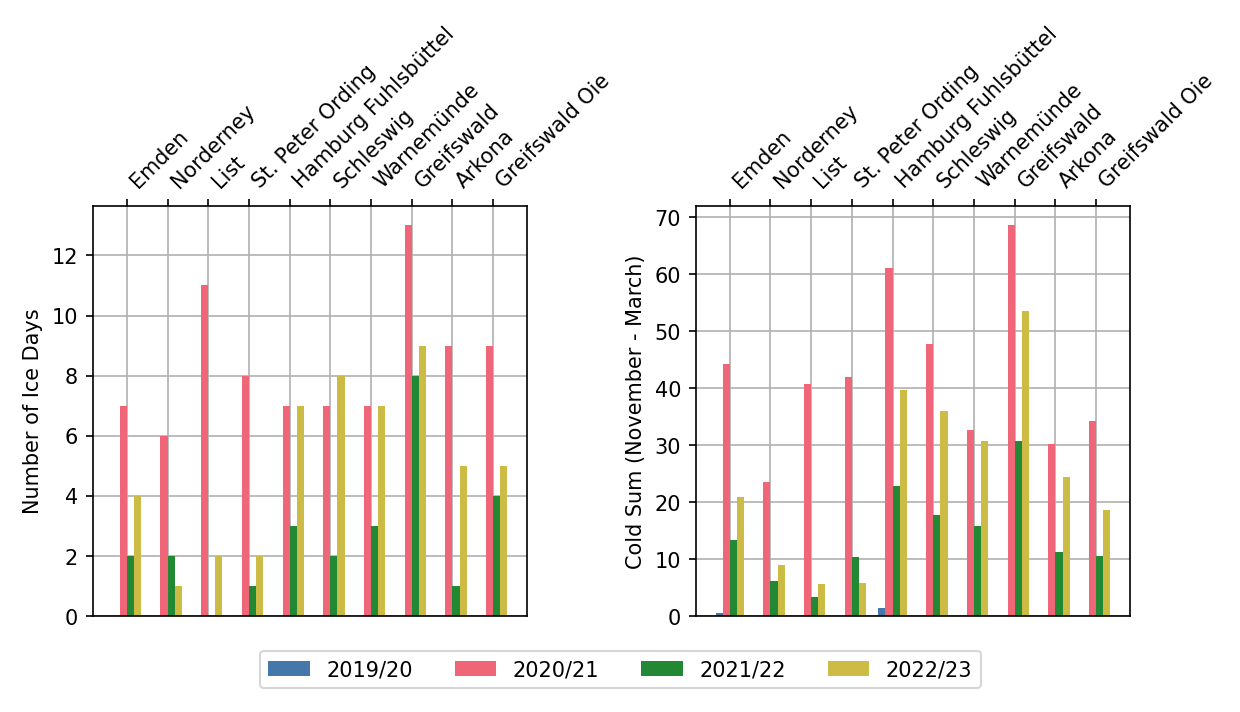
Figure 2 shows the number of ice days, days with maximum temperature below the freezing point, and the cold sum, absolute value of the negative daily mean temperatures, of the stations Emden, Norderney, List, St. Peter Ording, Hamburg Fuhlsbüttel, Schleswig, Warnemünde, Greifswald, Arkona and Greifswalder Oie for the last four winters. In comparison with the last winters, the winter 2022/23 had more ice days than 2019/20 and 2021/22, but mostly fewer ice days than the winter 2020/21. The same pattern is reflected by the cold sum. The cold sum is also a mesure for the strength of a winter. The last four winters of the listed stations are all classified as a mild winter with a cold sum below 100.
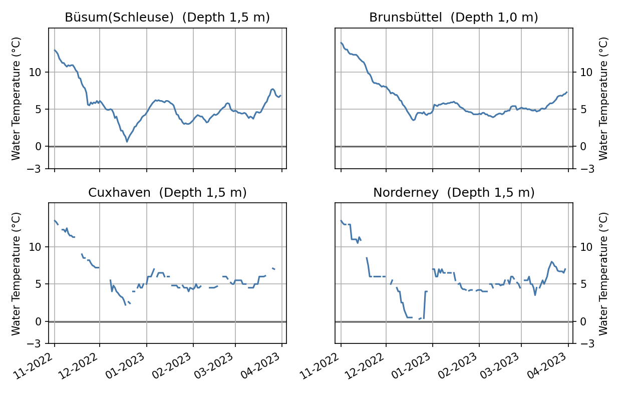
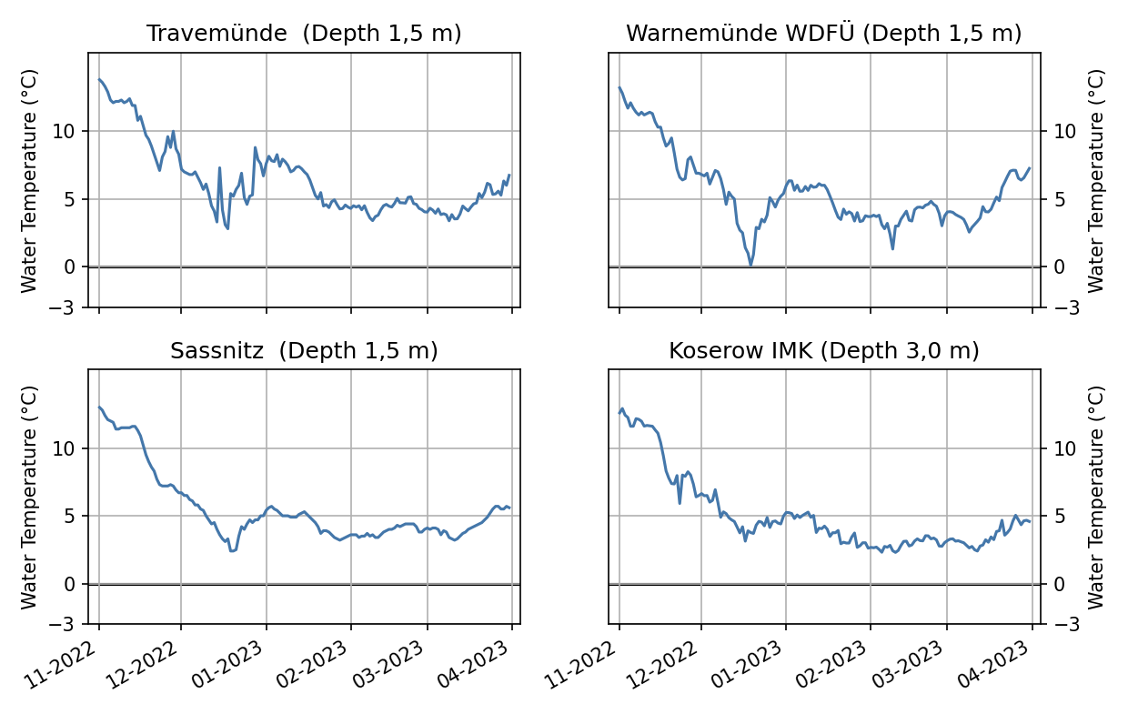
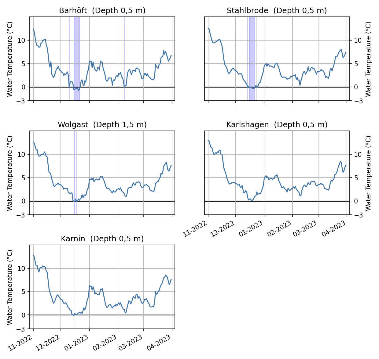
If sea ice forms, depends on the water temperature. Sea ice formation may start once the freezing point is reached. For saline water, the freezing point is below 0°C. Besides the temperature, the sea state also affects the formation of ice as ice formation may be delayed on rough seas. The water temperatures in depths of 1 m to 1.5 m of the stations Büsum (Schleuse), Brunsbüttel, Cuxhaven and Norderney in the North Sea are shown in Figure 3. The water temperatures for the staions Travemünde, Warnemünde, Sassnitz and Koserow (depths from 1.5 to 3 m) along the Baltic sea coast and for the stations Barhöft, Stahlbrode, Wolgast, Karlshagen and Karnin in the Bodden waters and the western Szczecin Lagoon in 0.5 m depths are shown in Figure 4 and Figure 5, respectively. The water temperatures generally follow the pattern of the air temperature. In November, the temperatures continuously fell in all coastal areas. The cold period in December with the following higher air temperatures are well represented in the water temperatures of all stations. All stations reach their minimum water temperature during the cold period in December. Sub-zero temperatures are however only recorded for stations with the smallest sensor depths of 0.5 m in Barhöft, Stahlbrode, Wolgast and Karnin located in the Bodden waters and the Szczecin lagoon. In the further course of the winter temperatures stayed between 0 °C and 5 °C along the Baltic sea coast and around 5 °C along the North Sea coast. Generllay the water temperatures changed little throughout the rest of the winter and were following the patterns of the air temperature. Water temperatures started to increase continuously around mid-March.
2.2 Ice conditions at the German North Sea and Baltic Sea coasts
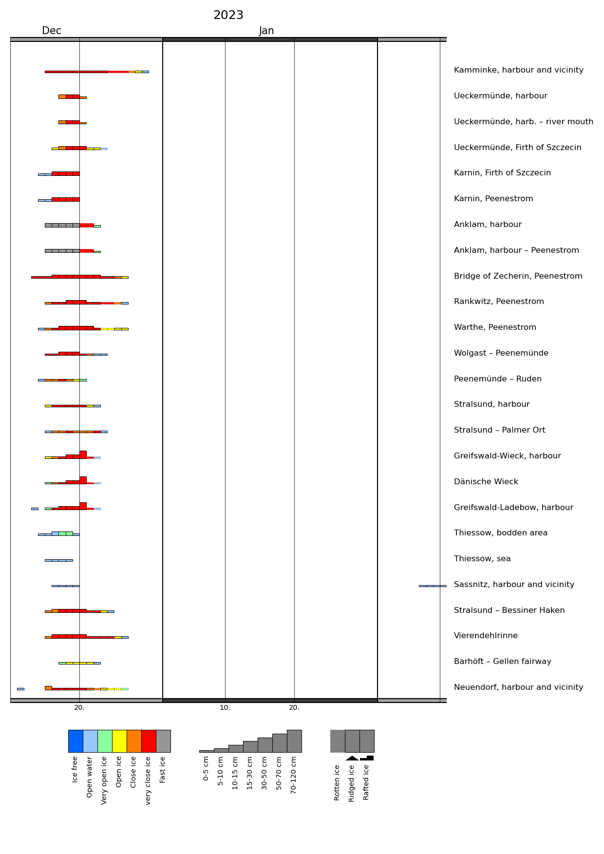
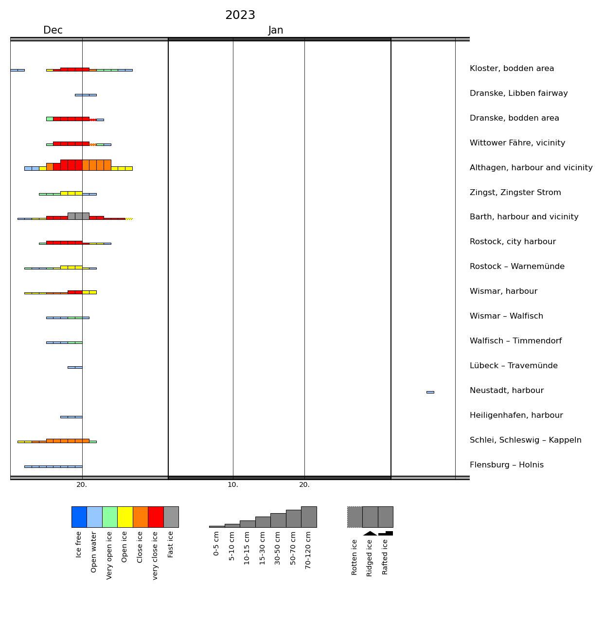
In accordance with the weather conditions, the ice winter 2022/23 was a mild ice winter. Noteworthy ice formation along the German coasts only occurred during the cold period in December. At that time, a closed ice layer formed in the Szczecin Lagoon, the river Peene with the Achterwasser, the Bodden waters around Rügen, the Darß-Zingst-Bodden-Chain and the Schlei. Ice also formed in sheltered places along the Baltic Sea and North Sea coasts. In the first third of February, some ice formed along the shores in sheltered inner waters around Rügen and the Achterwasser as well as in a few harbours.
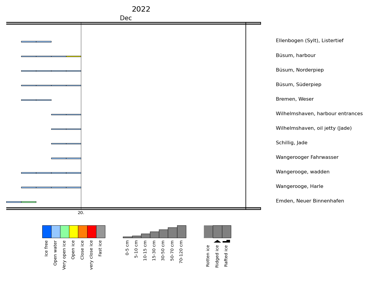
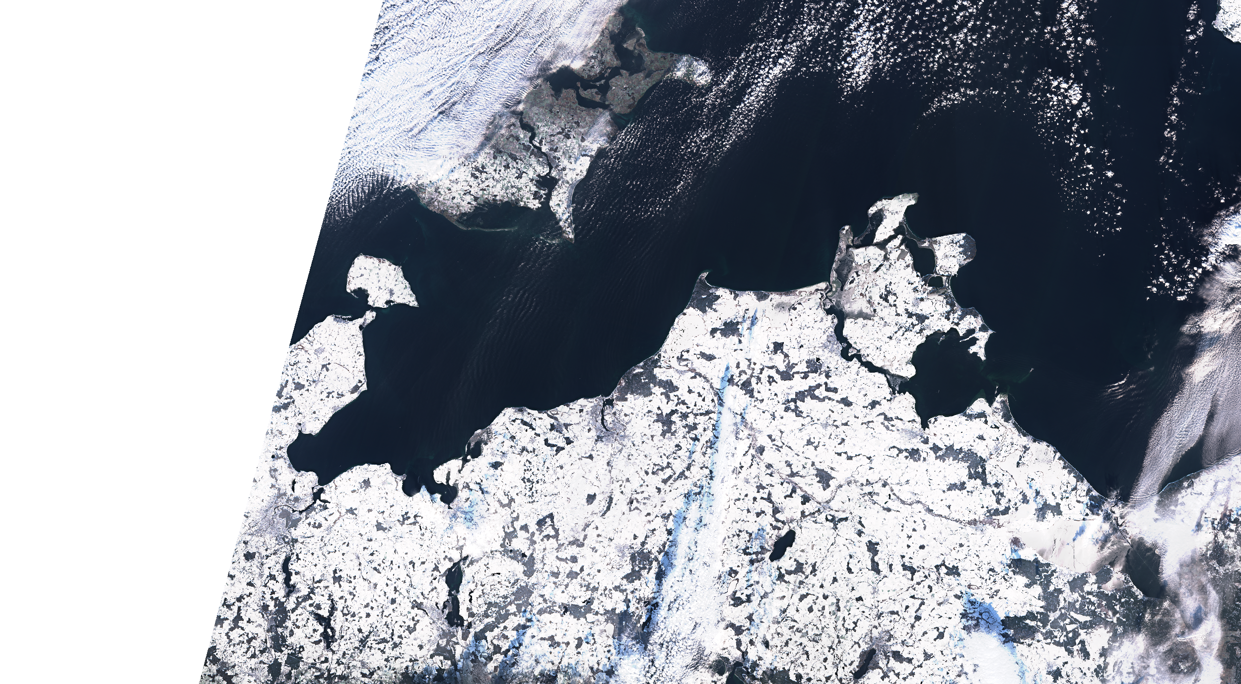
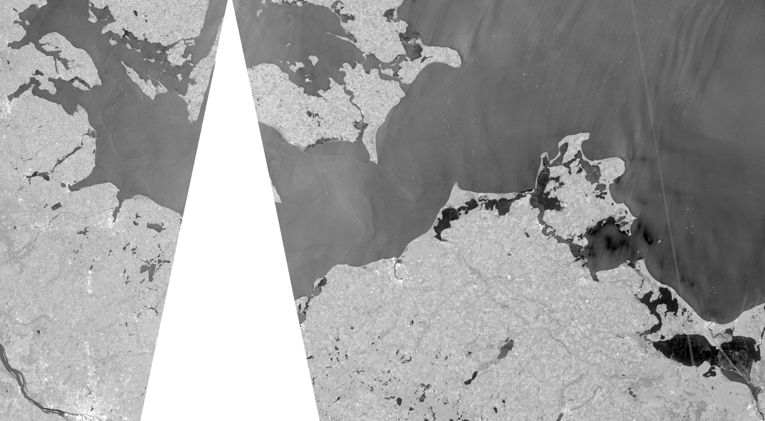
The first ice of the season occurred at places along the Baltic sea coast around 10 December 2022. Ice formation along the entire coast started around 13/14 December 2022. At the North sea, ice fromation started around 15/16 December 2022. Figure 6 shows the ice situation from Fehmarn to the Szczecin Lagoon on 17 December 2022 by a Sentinel-2 optical image. The ice in the Darß-Zingst-Bodden-Chain, the river Peene and the western part of the Szczecin Lagoon are already covered by a layer of snow and is therefore almost indistinguishable from the surrounding snow covered land. Thinner ice around Rügen and in the Szczecin Lagoon is represented by a more greyish tone while very thin ice is hardly distinguishable from the water without zooming in. On a closer look, some lighter thin features are visible that occur i.e. when thin ice gets rafted. 17 December 2022 is just before the maximum ice extent of the winter is reached on 19 December 2022 and the ice situation didn't change much the following days.
The thin ice in the North Sea quickly vanished with significantly raising temperatures and rain starting on 19 December 2022. Along the Baltic Sea coast of Schleswig-Holstein with exceopt of the inner Schlei, the ice also thawed quickly and most of it was gone by 20 December 2022. Along the coast of Mecklenburg-Vorpommern, the ice persisted slightly longer especially in sheltered areas of the Bodden waters and the Szczecin Lagoon. Most of the ice was gone by 27 December 2022. In the Achterwassser and along the northern shore of the Szczecin Lagoon some ice remnants were present until the turn of the year. The last station that reported ice was Kamminke (harbour and vicinity) on 27 December 2022. The maximum ice thicknesses were reached in the Bodden waters and the Szczecin lagoon with about 10 cm and thicker ice at a few places. This thicker ice in sheltered places remained until the end of the ice season.
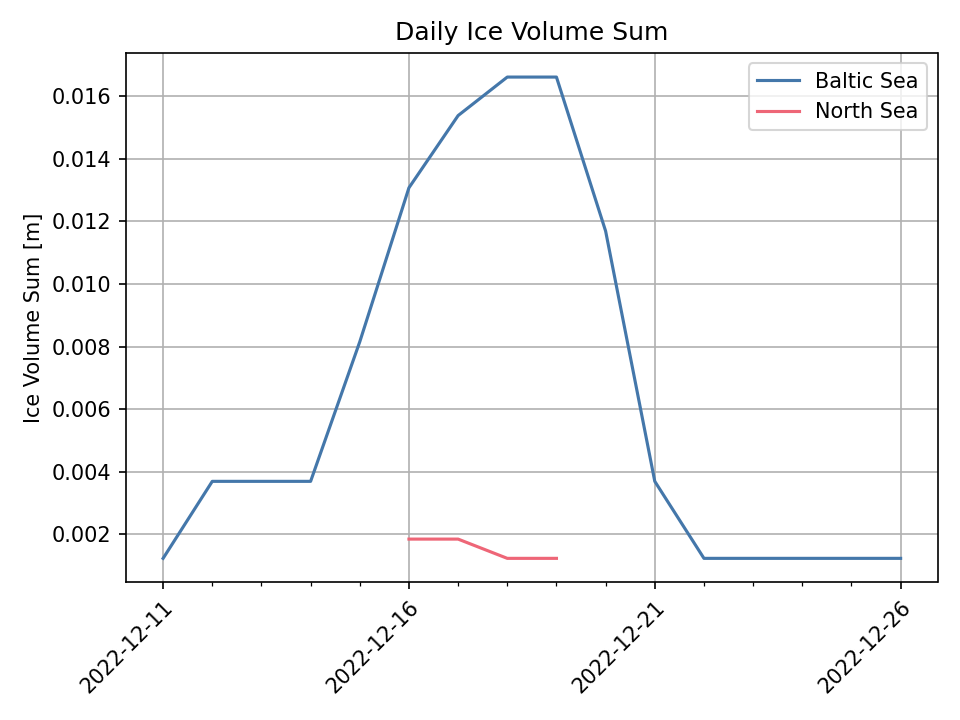
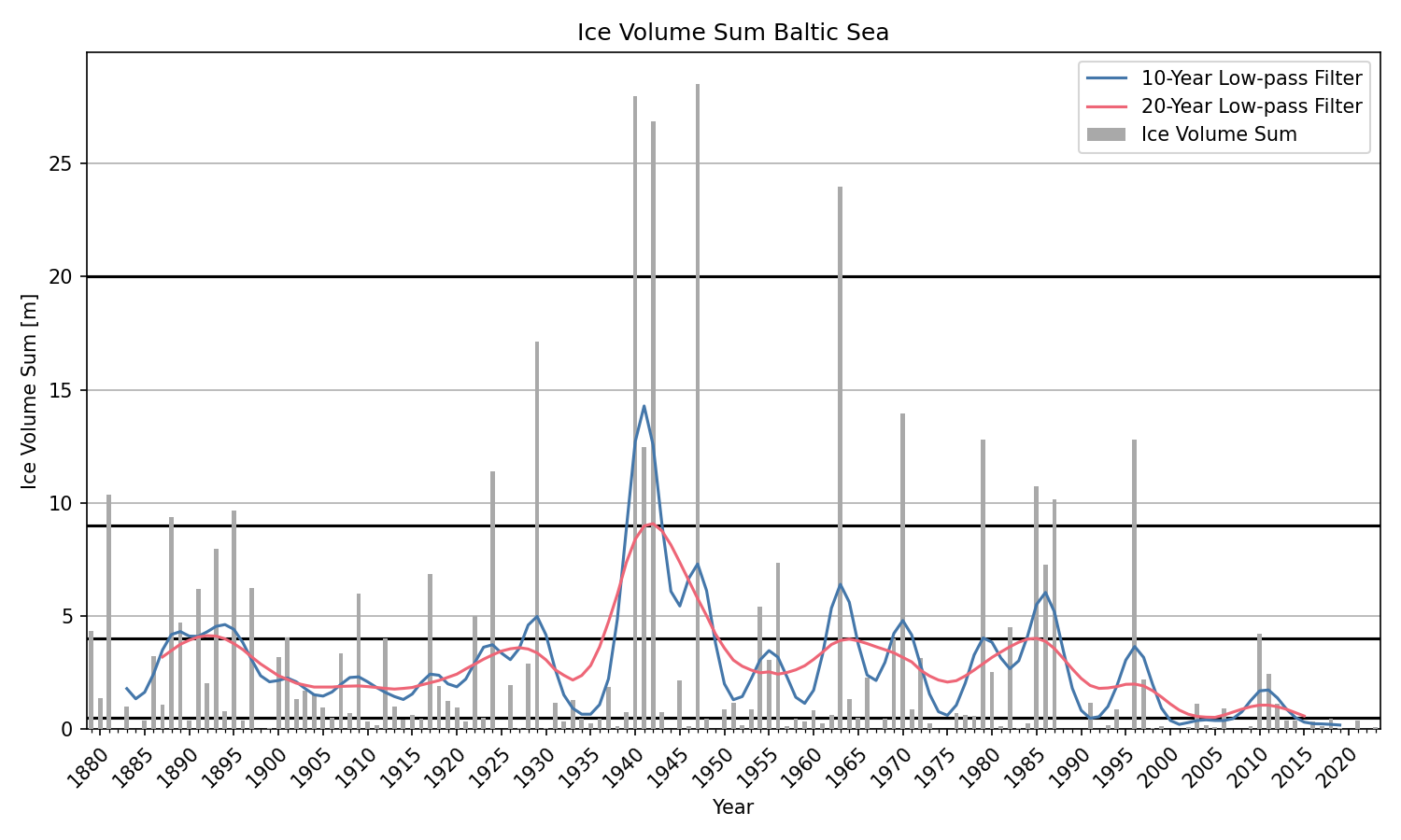
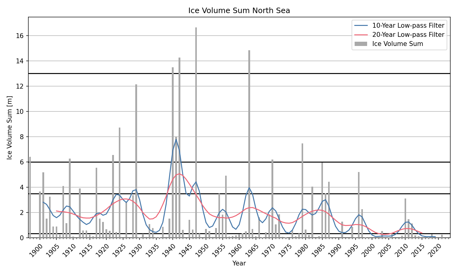
The course of the ice winter is also reflected by the daily areal ice volume sum. The areal ice volume sum is a measure to determine the ice winter strength that depends on the ice thickness, the ice concentration and the duration of the ice occurance [3]. The ice volume sum is calclated at 13 ice climate stations along the North Sea and Baltic Sea coast, respectively. Along the North Sea coast the following stations are used for the calculation: Borkum/Westerems, Emden (Ems and outer harbour), Norderney/Seegat, Wangerooge/wadden, Lighthouse Hohe Weg, Brake (Weser), Helgoland, Stadersand/Elbe, Brunsbüttel, Hamburg/Landungsbrücken, Husum (harbour), Amrum/Schmaltief and Tönning (harbour). Along the Baltic Sea coast the following stations are used: Koserow, Arkona, Landtiefrinne, Vierendehlrinne, Warnemünde/sea area, Rostock-Warnemünde, Walfisch-Timmendorf, Travemünde-Lübeck, Marienleuchte/sea area, Westermarkelsdorf/sea area, Eckernförde (harbour), Schleimünde-Schleswig and Flensburg-Holnis. The only station to report ice in the North Sea for the ice winter 2023 was Wangerooge/wadden. In the Baltic Sea, ice was observed at five stations: Vierendehlrinne, Rostock-Warnemünde, Walfisch-Timmendorf, Travemünde-Lübeck and Flensburg-Holnis. In Figure 8 the daily ice volume sum is shown for the North Sea and the Baltic Sea.
Overall, 54 of 123 ice stations along the North Sea and Baltic Sea coast reported ice during the winter 2022/23. Twelve of these stations were located in the North Sea and 42 in the Baltic Sea. The most days with ice were observed at the station Barth with 16 days and at the stations Althagen and Kamminke(harbour and vicinity) with 15 days. In the North Sea, four days of ice were observed at the stations of Büsum (harbour, Norderpiep and Süderpiep) and Wangerooge (wadden und Harle). An overview of all German ice observation stations that reported ice this winter is given in the appendices A und B.
2.3 Navigational conditions at the North Sea and Baltic Sea
Navigation in German coastal waters was no significantly impacted by the ice conditions in the winter 2022/23. At times ferry traffic in the western area of Rügen operated in an open lead without assistance. Some ice breaking was done in the river Peene by a multi-purpose vessel. Small and leisure boat traffic was affected by the ice conditions in areas with a closed ice cover in the Bodden waters, the river Peene and the Szczecin Lagoon.
2.4 Ice winter severity
The ice winter severity along the German coasts is determined by the accumulated areal ice volume sum of 13 ice climate stations for the North Ses and Blatic Sea (see 2.2). The ice winters are than classified in five categories: weak, moderate, severe, very severe and extremely severe. The accumulated ice volume sum for both coasts is shown in Figure 9. The ice volume sum in the North Sea 2022/23 was 0.006 m and the ice winter was therfore a weak ice winter. The winter in the Baltic Sea was also a weak ice winter with an ice volume sum of 0.1 m. The ice winter 2022/23 at both coasts were the eleventh weak ice winters in a row.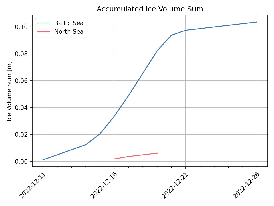
3 Ice conditions in the western and southern Baltic Sea, Kattegat and Skagerrak
In the Skagerrak and Kattegat, ice that was mostly thin occurred only occasionally during the winter. Yet, in some inner fjords and sheltered areas along the Norwegian coast fast ice formed and persisted at places from mid-December to beginning of April. In Danish waters and along the Swedish south coast to Kalmar in the north, there was some new ice during the cold period in December. In the lagoons from the Polish to the Lithuanian coast, an up to 10 cm thick, closed ice cover formed during December. Ice formation in the Curonian Lagoon started slightly earlier than in the more western lagoons. The Szczecin Lagoon was ice-free by the end of December except of some ice remnants along the northern shore. In the Vistula Lagoon, the ice persisted until the beginning of January. In the Curonian Lagoon most of the ice was gone by mid-January but some drifting ice survided to the end of January. At Sea, no significant ice formed from the Skagerrak to the Southeast Baltic Sea. Therfore, there were no restrictions or obstructions to navigation in the area. At some coastal areas with closed ice cover and in places along the Norwegian coast, small boats and leisure crafts were affected by the ice.
4 Ice conditions in the northern Baltic Sea
The ice season in the entire Baltic Sea was overall a mild one, eventhough the Bay of Bothnia and the Quark were at times completely covered by ice. Further south from the Sea of Bothnia to the Central Baltic Sea and the Gulf of Riga there was almost no ice formation outside the coastal areas. In the Gulf of Finland, drift ice was most of the winter only present in the eastern part.
The ice season in the Baltic Sea started in the northern Bay of Bothnia on 15 November 2022. First at the end of November ice formation advanced further south to the Quark. In the Gulf of Finland ice formation started around 20 November 2022 in St. Petersburg and the Bay of Vyborg. In the Gulf of Riga, the first ice occurred around 5 December 2022 in the Bay of Pärnu and the Väinameri. With the cold period in the second third of December, ice formation in coastal areas extended southward to the Western Baltic. At that time, the first ice also formed on Lake Mälaren and Lake Vänern.
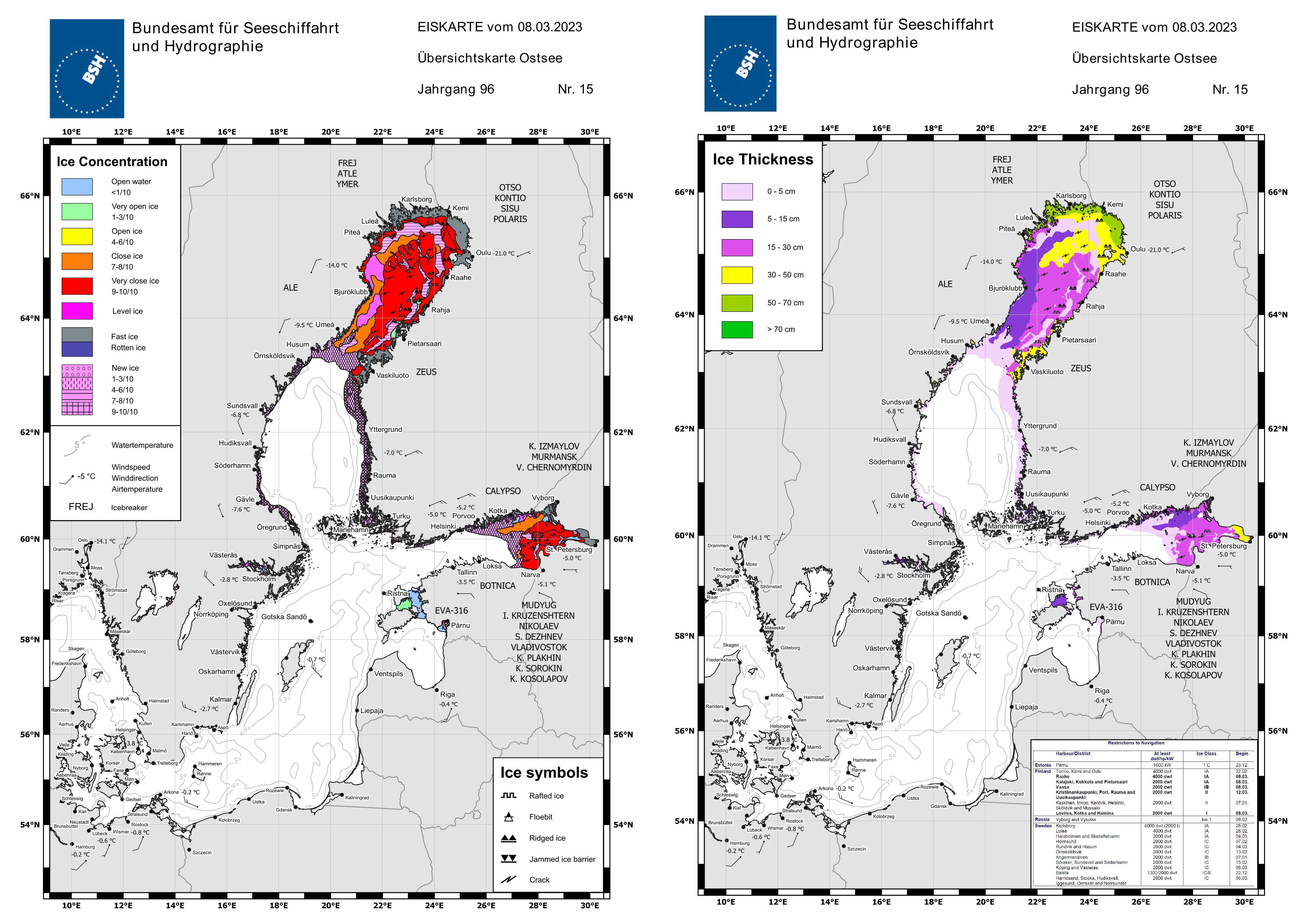
In the Western and Southern Baltic the ice vanished by the end of December and in the Southeastern Baltic some ice remnants were present to the end of January. Meanwhile the ice extent in the Bay of Bothnia and the Gulf of Finland increased only slowly during January. Southerly winds brought warmer temperatures and the ice was compacted along the northern shores. In the beginning of February, ice formation increased in the northern and eastern Baltic Sea. Strong southerly/southeasterly winds however forced the drift ice consistently northwards/northeastwards so that no closed ice cover could form in these areas. From mid-February onwards, the ice cover in the northern Baltic Sea extended continuously and finally reached its maximum on 12 March 2023. The ice chart with the maximum ice extent issued by the BSH on 8 March 2023 is shown in Figure 12. March was colder than usual especially in the Bay of Bothnia so that the ice extent steadily increased in the first half of March.
In the Gulf of Riga and the Northern Baltic including Lake Vänern the ice vanished relatively quickly until the end of March. In Lake Mälaren some rotten ice persisted until mid-April. In the Gulf of Finland the ice cover decreased continously after reaching its maximum. Easterly winds in the first half of April pushed the ice westwards were it melted quickly. In the Sea of Åland, the Archipelago Sea and the Sea of Bothnia the sea ice decreased during April. By the end of April, the Baltic Sea up to the Quark was ice free except some rotten fast ice in sheltered bays along the Swedish coast. The Bay of Bothnia was covered area-wide with ice for some time after the maximum ice extent. Around mid-April, the ice drifted westward and a large lead with very open ice formed along the eastern coast. At the beginning of the last third of April melting started in the area and the drift ice started to open on a large scale. With the beginning of May, the ice at sea decreased quickly and the fast ice started to get rotten. Mid-May, there was only rotten fast ice in the northern part and at the end of May, the Baltic Sea was ice free.
The fast ice in the Bay of Bothnia reached thicknesses of 70 cm and up to 40 cm in the Gulf of Finland. The drift ice in the north was up to 65 cm thick and up to 30 cm in the Gulf of Finland.
Restrictions for navigation were in place in the northern Bay of Bothnia from the beginning of December and the last restrictions were lifted at the end of May for the northernmost Finnish harbours. At times, there were also resrictions for harbours along the Swedish and Finnish coast as south as the Northern Baltic and for the port Pärnu in the Gulf of Riga. In the Gulf of Finland, there were restrictions for russian harbours for small boats from end of November to April and later for larger vessels to the harbours of Vysotsk and Vyborg. At times, there were also restrictions to the Finnsish harbours. The Saimaa Canal was closed from 9 January 2023 to 1 May 2023.
5 Ice winter severity of the Baltic Sea
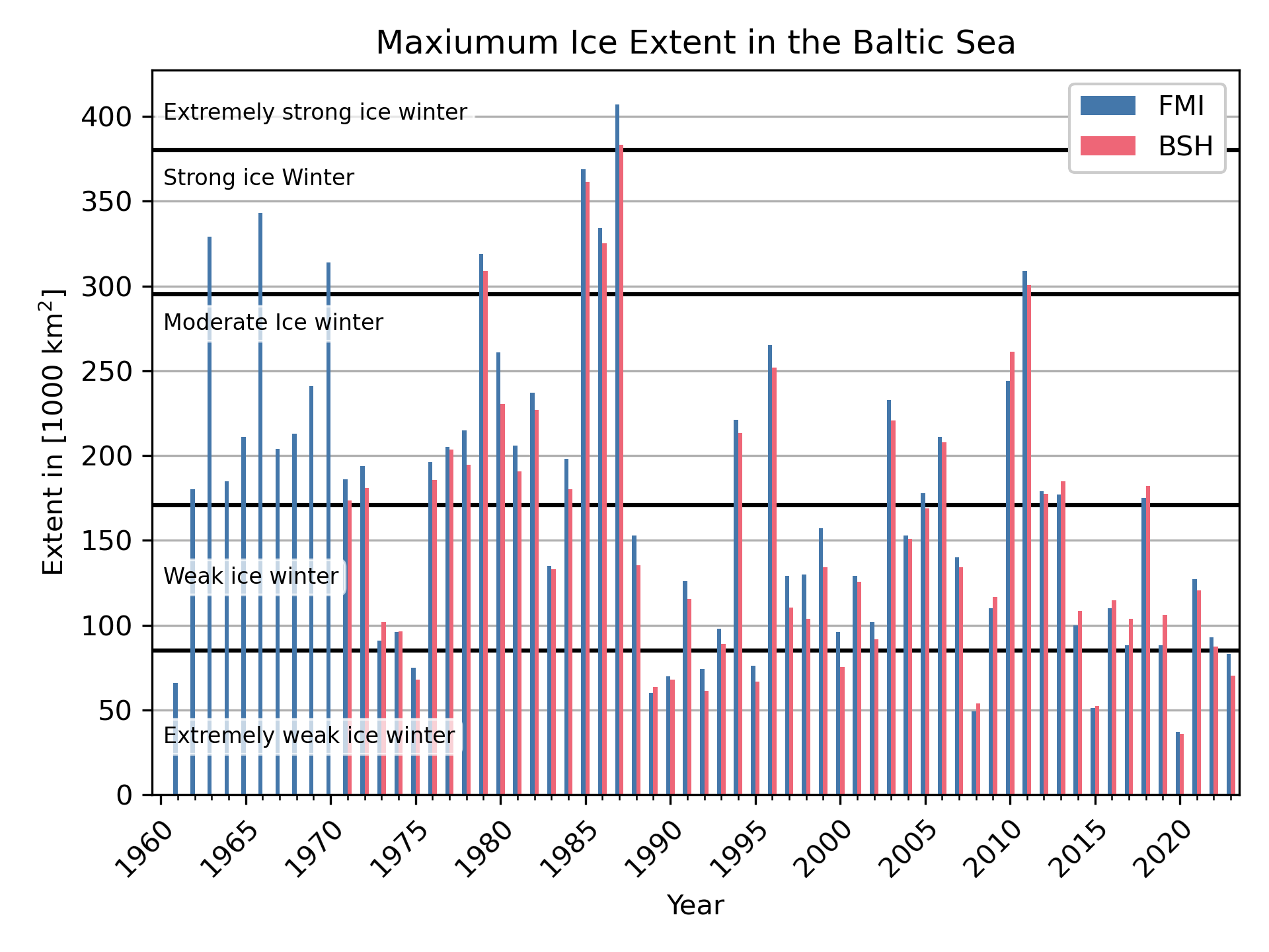
The strength of the ice winter of the entire Baltic Sea is determined by the maximum ice extent. The maximum ice extent of the Baltic Sea according to the daily Swedish and Finnish ice charts (SMHI and FMI respectively) was reached on 12 March 2023 and was 83000 km2. The maximum ice extent of the weekly ice charts of the BSH was reached on 8 March 2023 and was 70058 km2. The relatively large difference in maximum ice extent is explained by the time difference between the two charts. New ice formed in the Gulf of Riga, the Gulf of Finland and along the Swedish coast of the Sea of Bothnia during the days. Furthermore, there are generally differences due to the subjective interpretation of satellite imagery and other information, differences in the calculation techniques and the chosen land masks.A time series of the maximum ice extent from the FMI and the BSH since 1960 is shown in Figure 13. Both calculated maximum ice extents generally follow the same trend but are never equal.
6 Reporting of the BSH
The BSH informed about ice conditions and expected ice development in the entire Baltic Sea and German coastal waters by the following reports and ice charts:
The weekly report with a review and an outlook of the ice situation in the Baltic as well as with a glimpse of the ice situation at the poles is issued weekly throughout the year since 2022.
Bibliography
- Deutscher Wetterdienst (2023, 27. Februar), Deutschlandwetter im Winter 2022/23 [Pressemitteilung], https://www.dwd.de/DE/presse/pressemitteilungen/DE/2023/20230227_deutschlandwetter_winter22-23_news.html
- Deutscher Wetterdienst, Die Witterung in den deutschen Küstengebieten, https://www.dwd.de/DE/leistungen/witterungkueste/witterungkueste.html
- Koslowski, G., 1989: Die flächenbezogene Eisvolumensumme, eine neue Maßzahl für die Bewertung des Eiswinters an der Ostseeküste Schleswig-Holsteins und ihr Zusammenhang mit dem Charakter des meteorologischen Winters. Dt. hydrogr. Z. 42, 61-80
- Nusser, F., 1948: Die Eisverhältnisse des Winters 1947/48 an den deutschen Küsten. Dt. hydrogr. Z. 1, 149–156
Appendix
A. Ice conditions at the German coasts
| Begin | End | Days with ice | max.
ice thickness [cm] (Measurement) |
max.
ice thickness [cm]* (Baltic Sea ice code) |
|
|---|---|---|---|---|---|
| Althagen, harbour and vicinity | 12.12. | 26.12. | 15 | [—] | 30 |
| Anklam, harbour | 15.12. | 22.12. | 8 | 8.0 | 10 |
| Anklam, harbour – Peenestrom | 15.12. | 22.12. | 8 | 8.0 | 10 |
| Barhöft – Gellen fairway | 17.12. | 22.12. | 6 | [—] | 5 |
| Barth, harbour and vicinity | 11.12. | 26.12. | 16 | 11.0 | 15 |
| Bridge of Zecherin, Peenestrom | 13.12. | 26.12. | 14 | 6.0 | 10 |
| Dranske, Libben fairway | 19.12. | 21.12. | 3 | 5.0 | 5 |
| Dranske, bodden area | 15.12. | 22.12. | 8 | 5.0 | 10 |
| Dänische Wieck | 15.12. | 22.12. | 8 | 7.0 | 22 |
| Flensburg – Holnis | 12.12. | 19.12. | 8 | [—] | 5 |
| Greifswald-Ladebow, harbour | 13.12. | 22.12. | 9 | 7.0 | 22 |
| Greifswald-Wieck, harbour | 15.12. | 22.12. | 8 | 7.0 | 22 |
| Heiligenhafen, harbour | 17.12. | 19.12. | 3 | 1.0 | 5 |
| Kamminke, harbour and vicinity | 15.12. | 29.12. | 15 | [—] | 5 |
| Karnin, Firth of Szczecin | 14.12. | 19.12. | 6 | [—] | 10 |
| Karnin, Peenestrom | 14.12. | 19.12. | 6 | [—] | 10 |
| Kloster, bodden area | 10.12. | 26.12. | 14 | 8.0 | 10 |
| Lübeck – Travemünde | 18.12. | 19.12. | 2 | [—] | 5 |
| Neuendorf, harbour and vicinity | 11.12. | 26.12. | 13 | 4.0 | 10 |
| Neustadt, harbour | 06.02. | 06.02. | 1 | [—] | 5 |
| Peenemünde – Ruden | 14.12. | 20.12. | 7 | [—] | 5 |
| Rankwitz, Peenestrom | 15.12. | 26.12. | 12 | 6.0 | 10 |
| Rostock – Warnemünde | 12.12. | 21.12. | 10 | [—] | 10 |
| Rostock, city harbour | 14.12. | 23.12. | 10 | [—] | 10 |
| Sassnitz, harbour and vicinity | 16.12. | 10.02. | 8 | [—] | 5 |
| Schlei, Schleswig – Kappeln | 11.12. | 21.12. | 11 | 7.0 | 10 |
| Stralsund – Bessiner Haken | 15.12. | 24.12. | 10 | 5.0 | 10 |
| Stralsund – Palmer Ort | 15.12. | 23.12. | 9 | [—] | 5 |
| Stralsund, harbour | 15.12. | 22.12. | 8 | 3.0 | 5 |
| Thiessow, bodden area | 14.12. | 19.12. | 6 | [—] | 10 |
| Thiessow, sea | 15.12. | 18.12. | 4 | [—] | 5 |
| Ueckermünde, Firth of Szczecin | 16.12. | 23.12. | 8 | [—] | 10 |
| Ueckermünde, harb. – river mouth | 17.12. | 20.12. | 4 | [—] | 10 |
| Ueckermünde, harbour | 17.12. | 20.12. | 4 | [—] | 10 |
| Vierendehlrinne | 15.12. | 26.12. | 12 | 5.0 | 10 |
| Walfisch – Timmendorf | 15.12. | 19.12. | 5 | [—] | 5 |
| Warthe, Peenestrom | 14.12. | 26.12. | 13 | 10.0 | 10 |
| Wismar – Walfisch | 15.12. | 20.12. | 6 | [—] | 5 |
| Wismar, harbour | 12.12. | 21.12. | 10 | 8.0 | 10 |
| Wittower Fähre, vicinity | 15.12. | 23.12. | 9 | [—] | 10 |
| Wolgast – Peenemünde | 15.12. | 23.12. | 10 | [—] | 10 |
| Zingst, Zingster Strom | 14.12. | 21.12. | 8 | 8.0 | 10 |
| Begin | End | Days with ice | max.
ice thickness [cm] (Measurement) |
max.
ice thickness [cm]* (Baltic Sea ice code) |
|
|---|---|---|---|---|---|
| Bremen, Weser | 16.12. | 17.12. | 2 | [—] | 5 |
| Büsum, Norderpiep | 16.12. | 19.12. | 4 | [—] | 5 |
| Büsum, Süderpiep | 16.12. | 19.12. | 4 | [—] | 5 |
| Büsum, harbour | 16.12. | 19.12. | 4 | [—] | 5 |
| Ellenbogen (Sylt), Listertief | 16.12. | 17.12. | 2 | 5.0 | 5 |
| Emden, Neuer Binnenhafen | 15.12. | 16.12. | 2 | [—] | 5 |
| Schillig, Jade | 18.12. | 19.12. | 2 | [—] | 5 |
| Wangerooge, Harle | 16.12. | 19.12. | 4 | [—] | 5 |
| Wangerooge, wadden | 16.12. | 19.12. | 4 | 5.0 | 5 |
| Wangerooger Fahrwasser | 18.12. | 19.12. | 2 | [—] | 5 |
| Wilhelmshaven, harbour entrances | 18.12. | 19.12. | 2 | [—] | 5 |
| Wilhelmshaven, oil jetty (Jade) | 18.12. | 19.12. | 2 | [—] | 5 |
B. Baltic Sea ice codes of German stations.